california

Day 30: Joshua Tree National Park, CA by Wookie Kim

Normally, what follows would be merged with the rest of the day's post, but this morning was so spectacular that I decided I'd write separately about the first 45 minutes of my day.

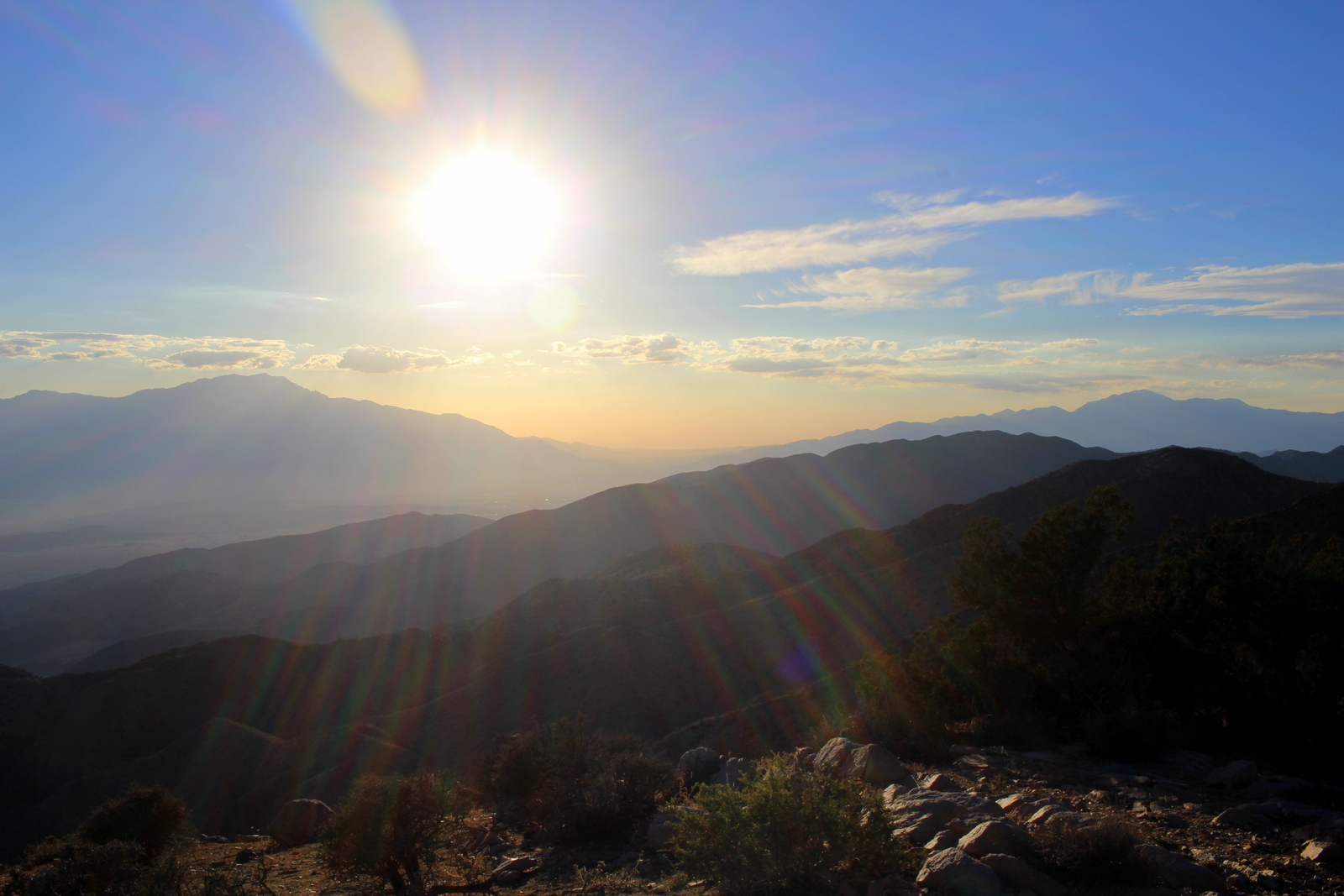
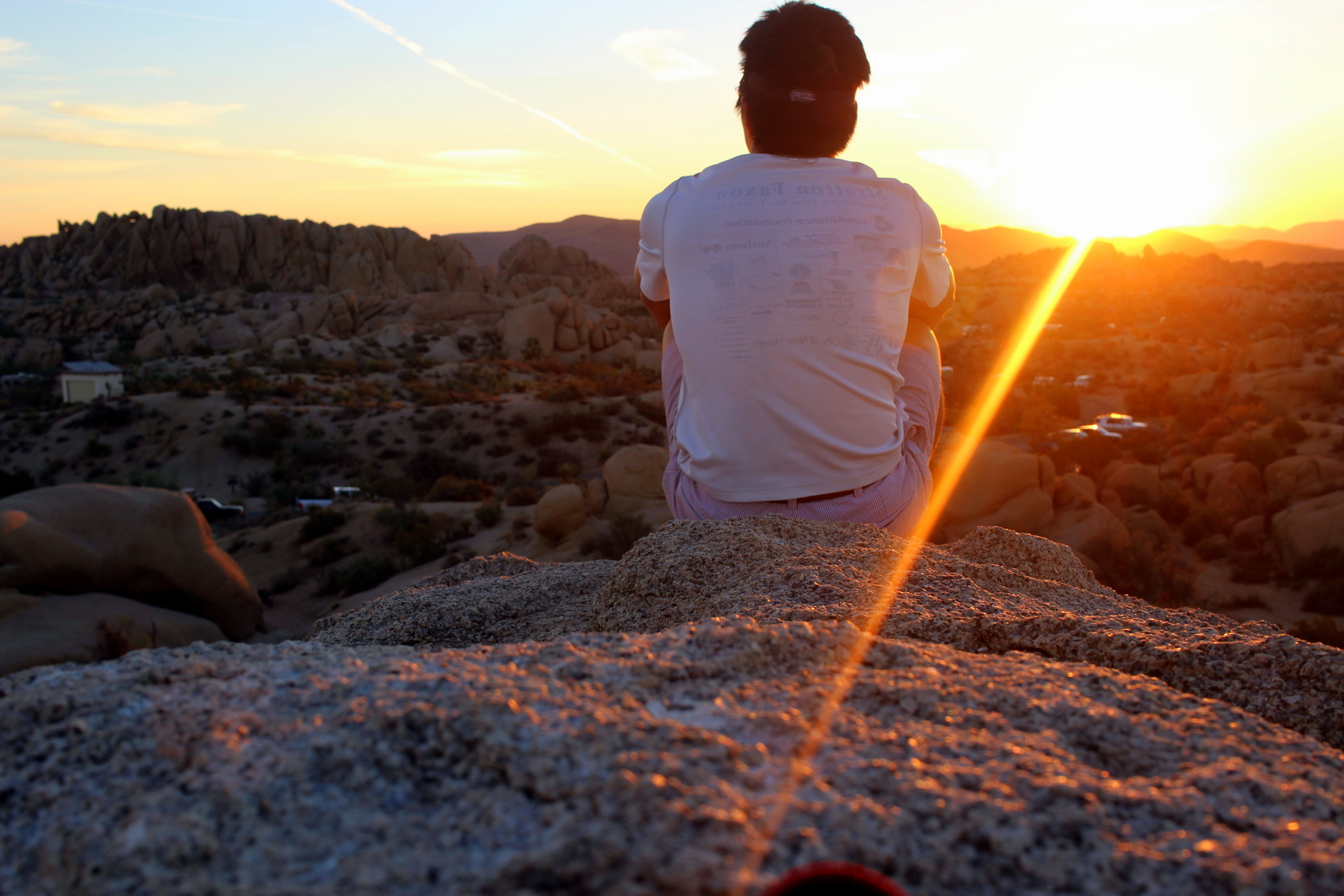
The previous night, I'd narrowly avoided either being stranded on top of a pile of rocks or falling off a cliff and badly hurting myself. This morning, I was ready to catch the sunrise from the same perch.

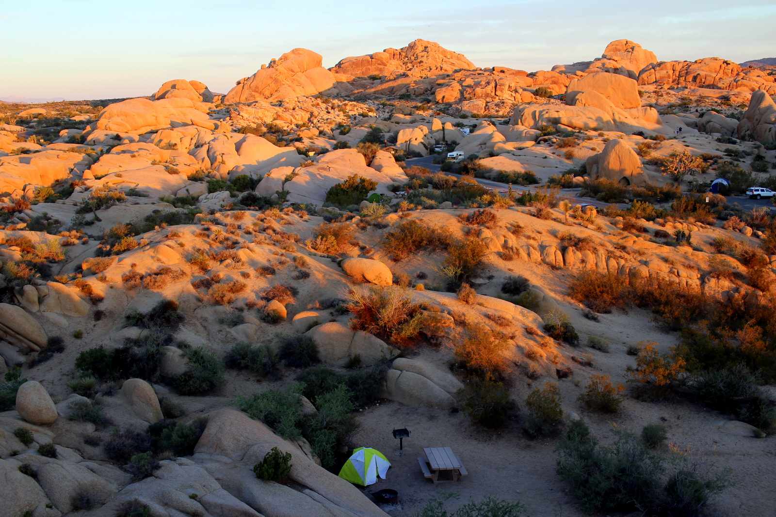
At 5:30 a.m., I was up and out of my tent. After using the bathroom and getting my camera gear ready, I made my way back up to the top of the rocks. I made it to the top at 5:59, and this was my first view of the campground.

6:00 a.m.

6:00 a.m.

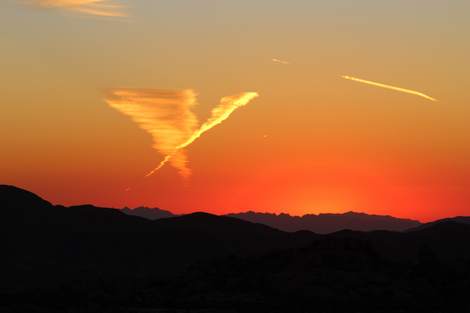
Official sunrise was not for another 15 minutes or so, so I scanned the area as my eyes adjusted to the dark. As the sky continued to turn colors, I noticed a strange cloud formation on the horizon. It looked like a mini-tornado.
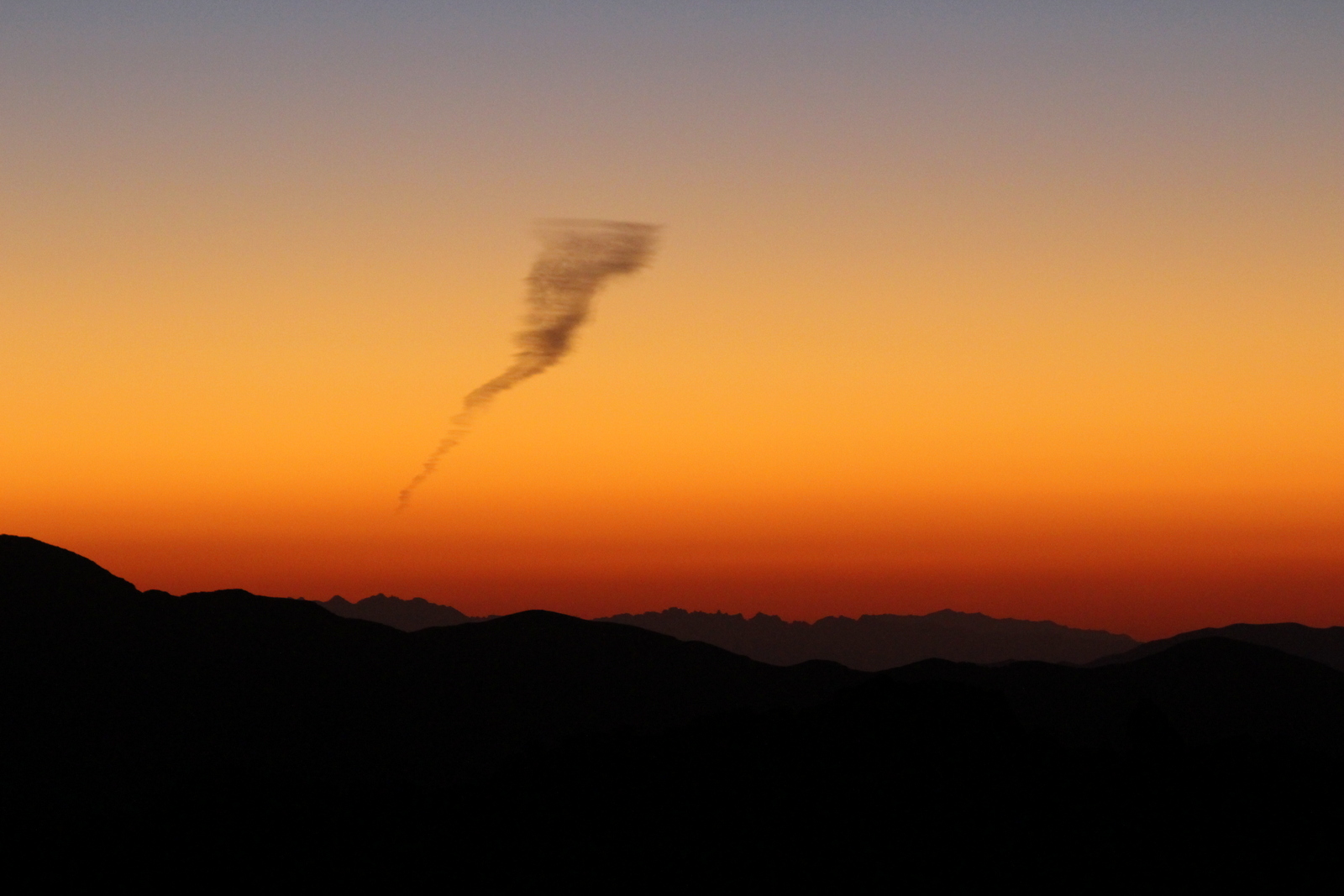
6:06 a.m.

6:06 a.m.

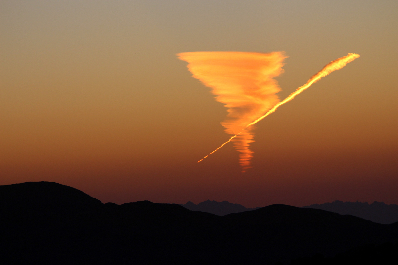
As the minutes ticked away, different parts of the tornado turned orange.

6:11 a.m.

6:11 a.m.

At some point, a plane started creating a streak across the sky that was on a collision course with the tornado.

6:15 a.m.

6:15 a.m.

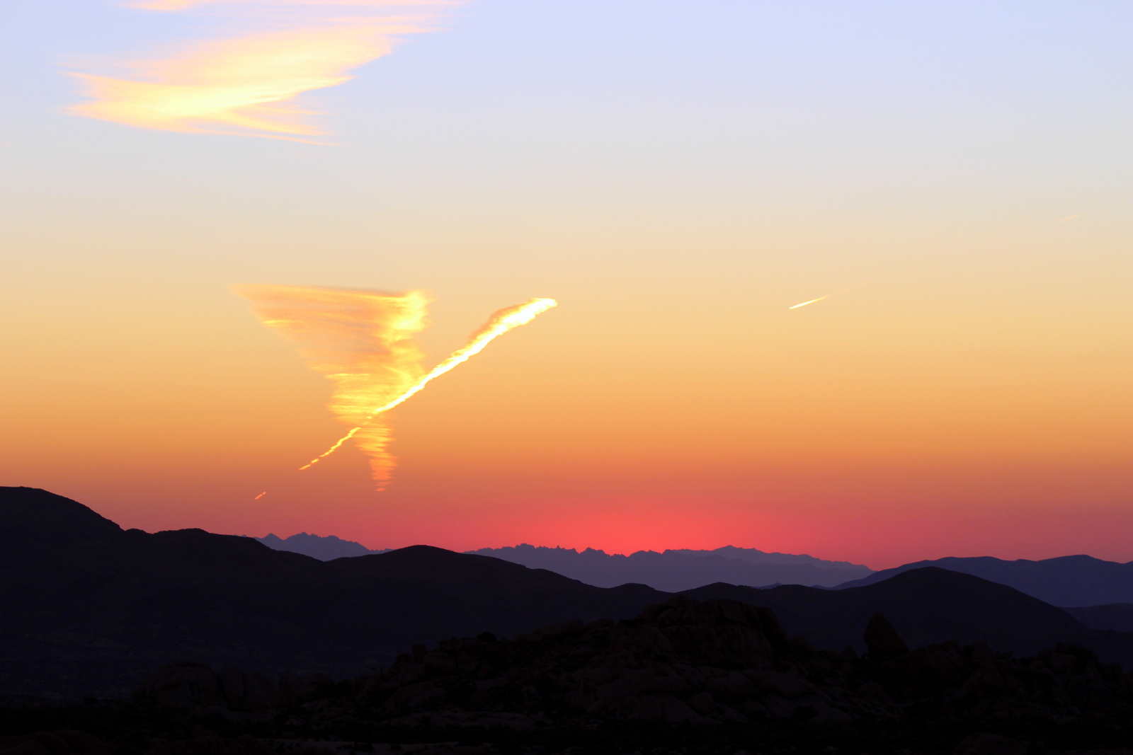
It was kind of surreal to see these formations against the landscape.

The campground was still dark at this point, but the horizon showed the hills with differing levels of faintness.

6:19 a.m.

6:19 a.m.

By now, others had joined the party. All around me, people were clambering up rocks to their respective viewpoints.

6:21 a.m.

6:21 a.m.

6:22 a.m.

6:22 a.m.

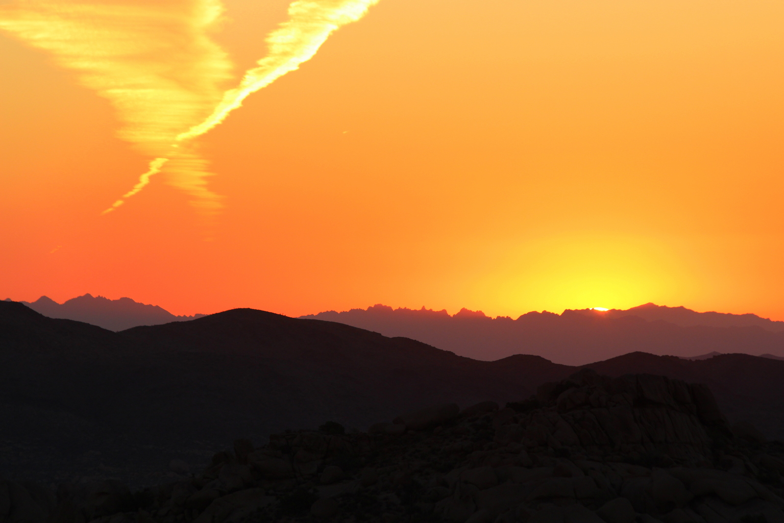
The plane eventually made it way past the tornado. It truly looked like some form of abstract art in the sky.

6:24 a.m.

6:24 a.m.

Looking away from the east, the clouds were a different color. Still beautiful.

6:25 a.m.

6:25 a.m.

Official sunrise was just a few minutes away. The last of the sunrise watchers clambered up to their perches.

6:26 a.m.

6:26 a.m.

And at 6:29, I saw something incredible. The horizon started glowing fiery red. Had I not known that the sun was rising, I would've thought an atomic bomb had just been dropped over there.

6:29 a.m.

6:29 a.m.

The camera didn't actually capture what I was seeing. It was a bright red spot glowing in the middle of on orange horizon. Truly incredible. I zoomed in on the epicenter. And I also looked at the horizon from a wide angle. Truly, these photos don't capture how bright the red glow was.

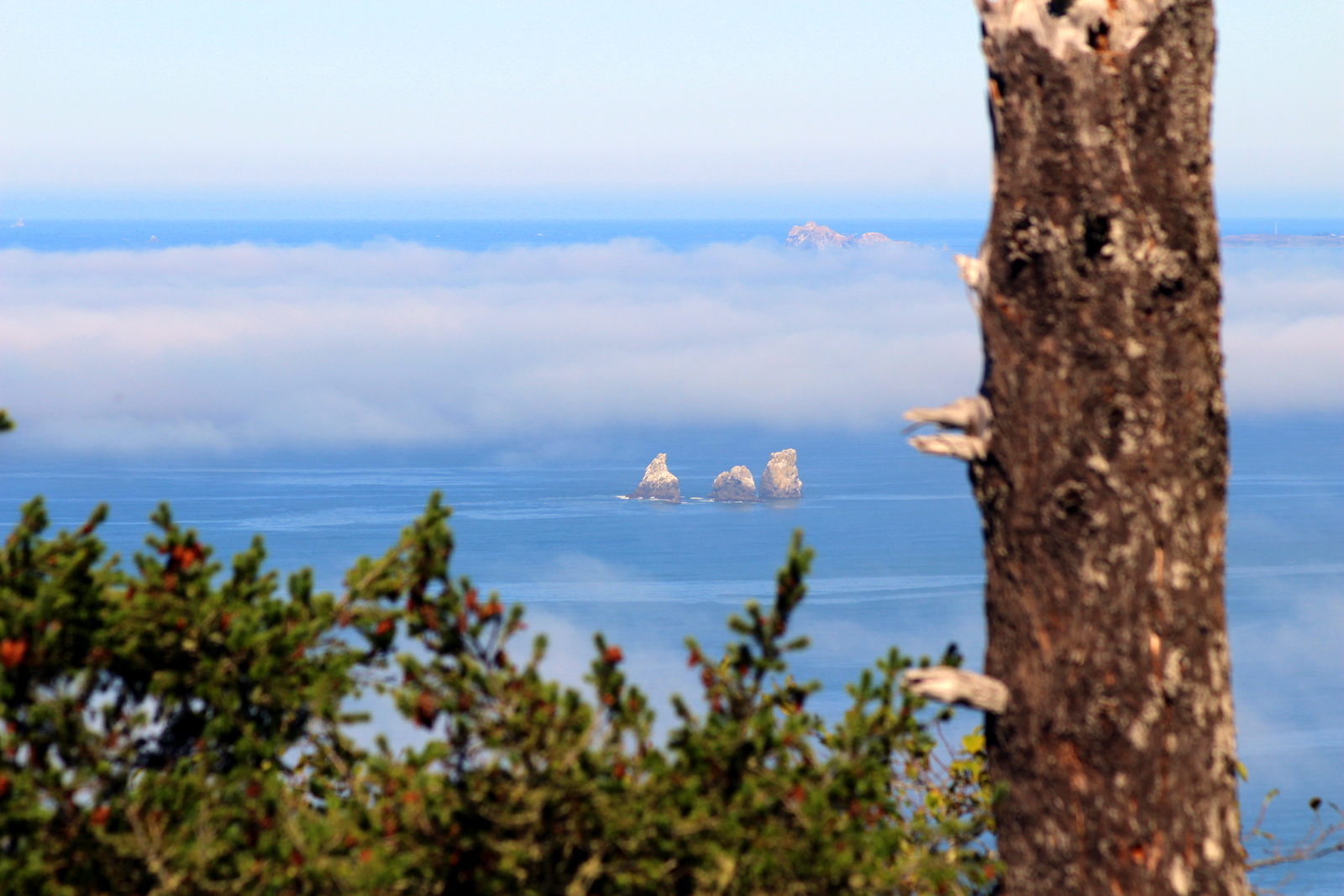
One upside to the smog is that it makes it easy to gauge distances. The succeeding layers of mountains grow fainter and fainter. I caught sight of a bird flying across, and managed to capture it against the hazy hills.

6:31 a.m.

6:31 a.m.

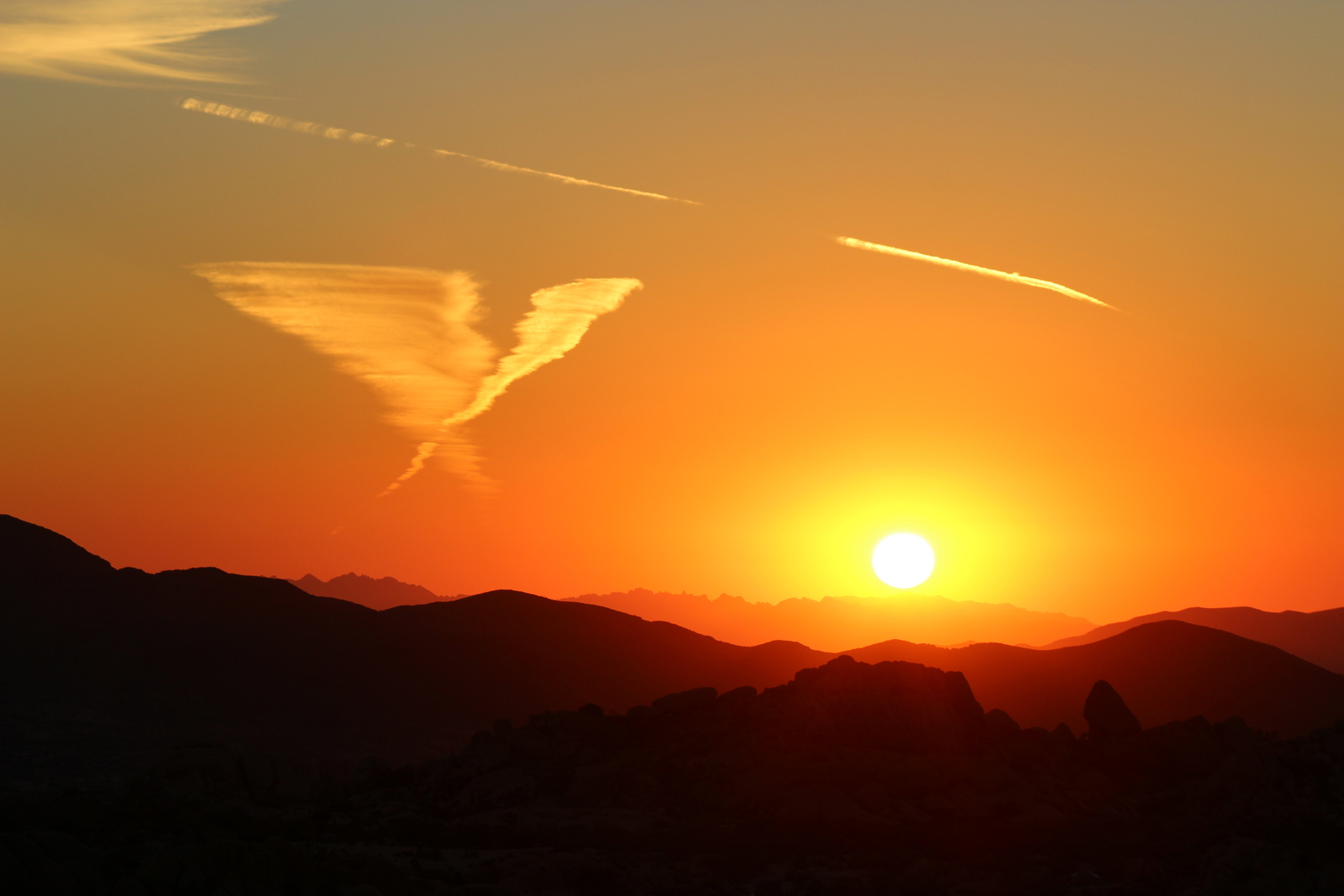
Within minutes, I could sense that the sun was about to peek over the hilltop. That section of the horizon was glowing a fiery red. 

6:32 a.m.

6:32 a.m.

Finally, the top edge of the sun poked out. It is amazing how quickly the sun moved in the span of 60 seconds.

6:34:01 a.m.

6:34:01 a.m.

6:34:22 a.m.

6:34:22 a.m.

6:34:51 a.m.

6:34:51 a.m.

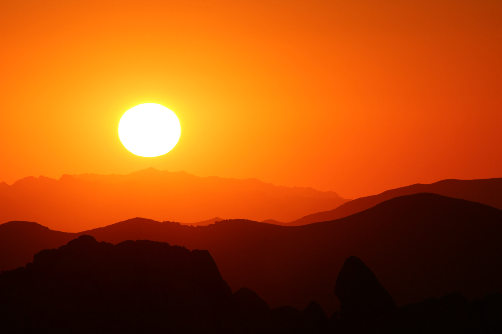
I think sunrises have been the favorite part of the day for me on this trip. I love being surrounded by darkness and then having the world light up around me. And the peace and solitude at this time of day is unparalleled. The sun continued its rapid ascent into the sky.

6:35:22 a.m.

6:35:22 a.m.

6:35:49 a.m.

6:35:49 a.m.

6:36:41 a.m.

6:36:41 a.m.

Finally, by 6:37 a.m., the sun was entirely visible in the sky. I loved the way its glow shaded the hills. 

6:37:04 a.m.

6:37:04 a.m.

6:37:22 a.m.

6:37:22 a.m.

The sun had not yet hit the campground. It was still quite dark.

6:38:30 a.m.

6:38:30 a.m.

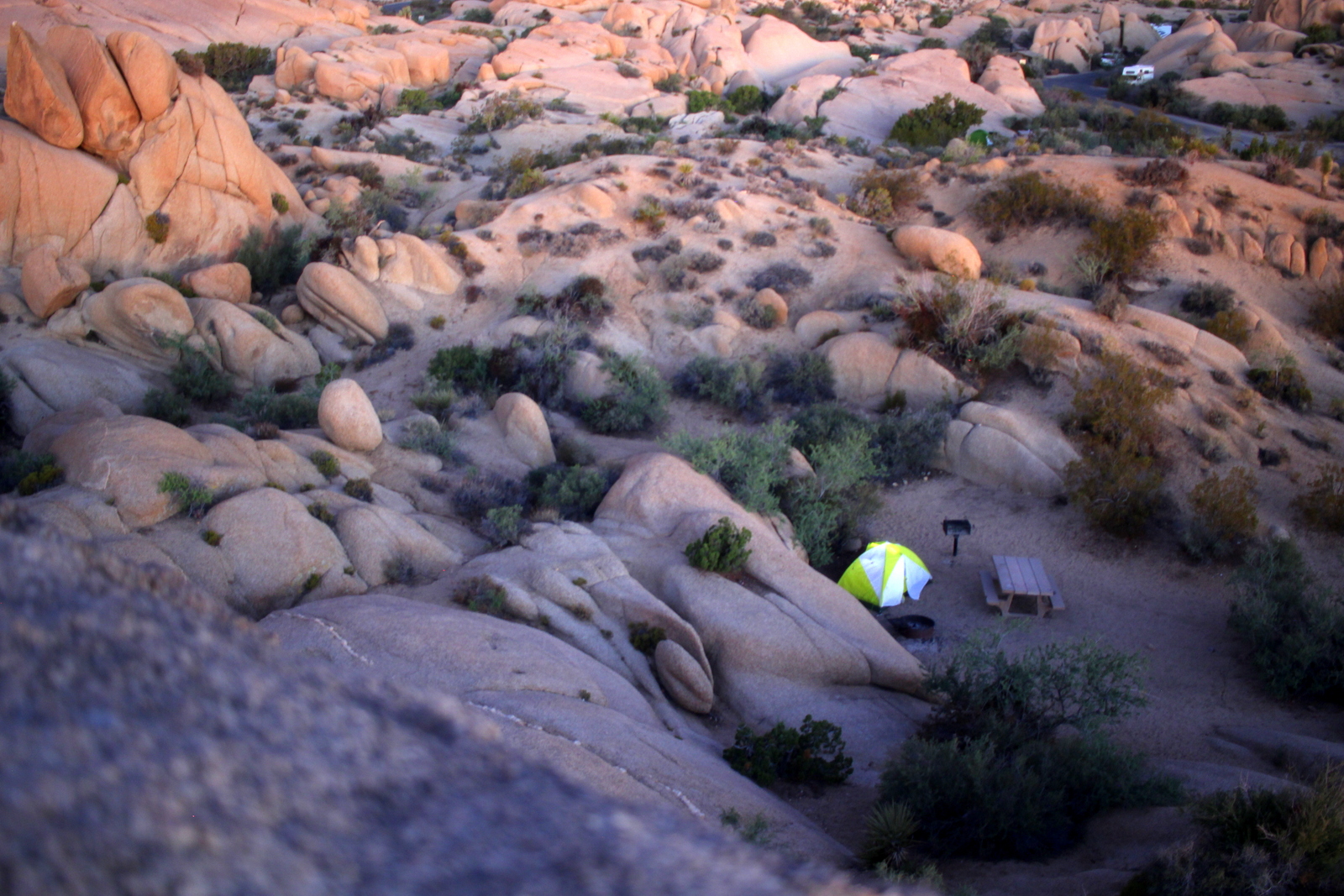
Now that the sun was completely up, I was ready to come down and eat. I really loved my perch way up above the rest of the Jumbo Rocks campground. It had taken some effort (and a huge scare) to get up here. But it was worth it.

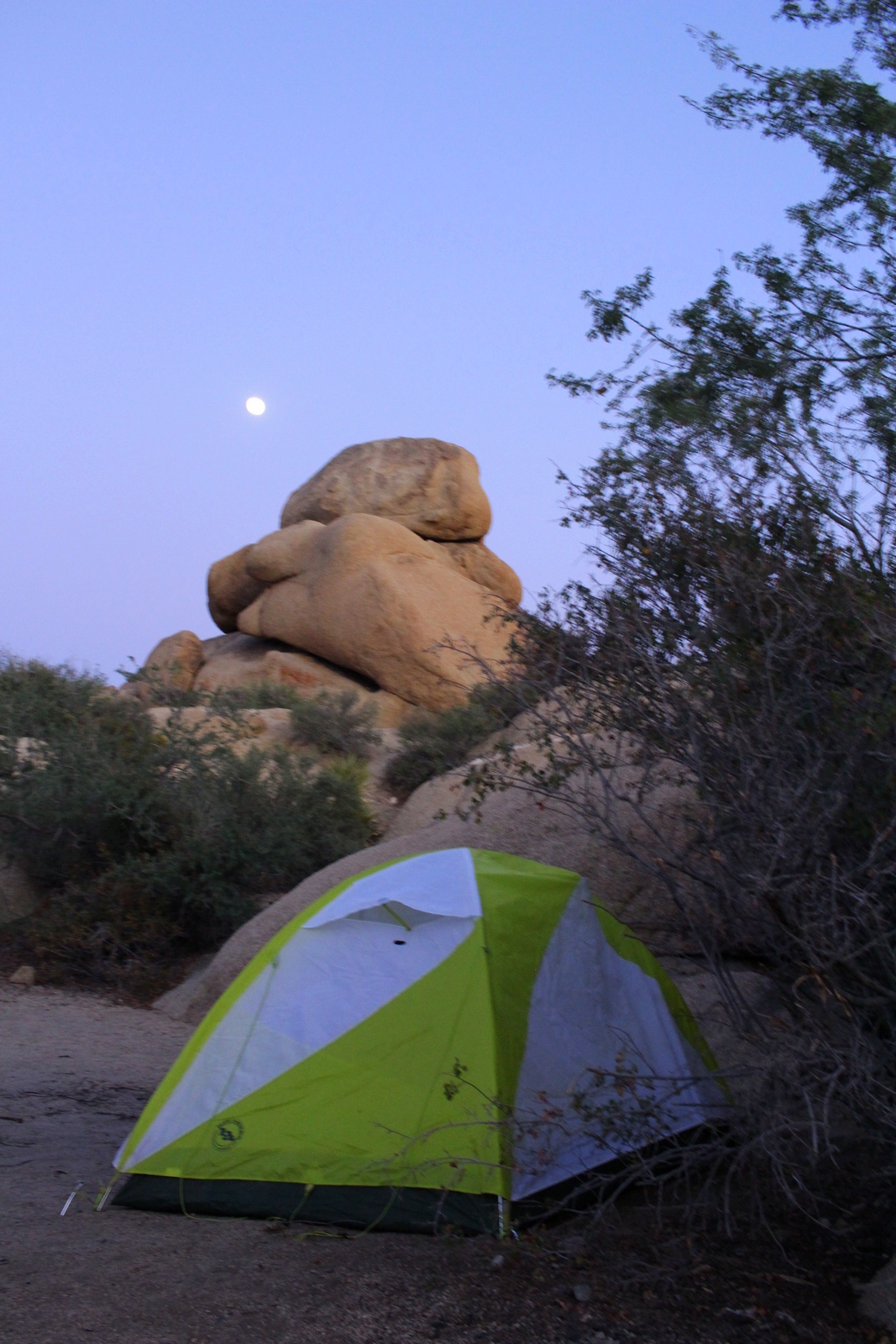
As I was about to descend, the first rays shone across the area (my tent is the white and green one in the bottom-center).

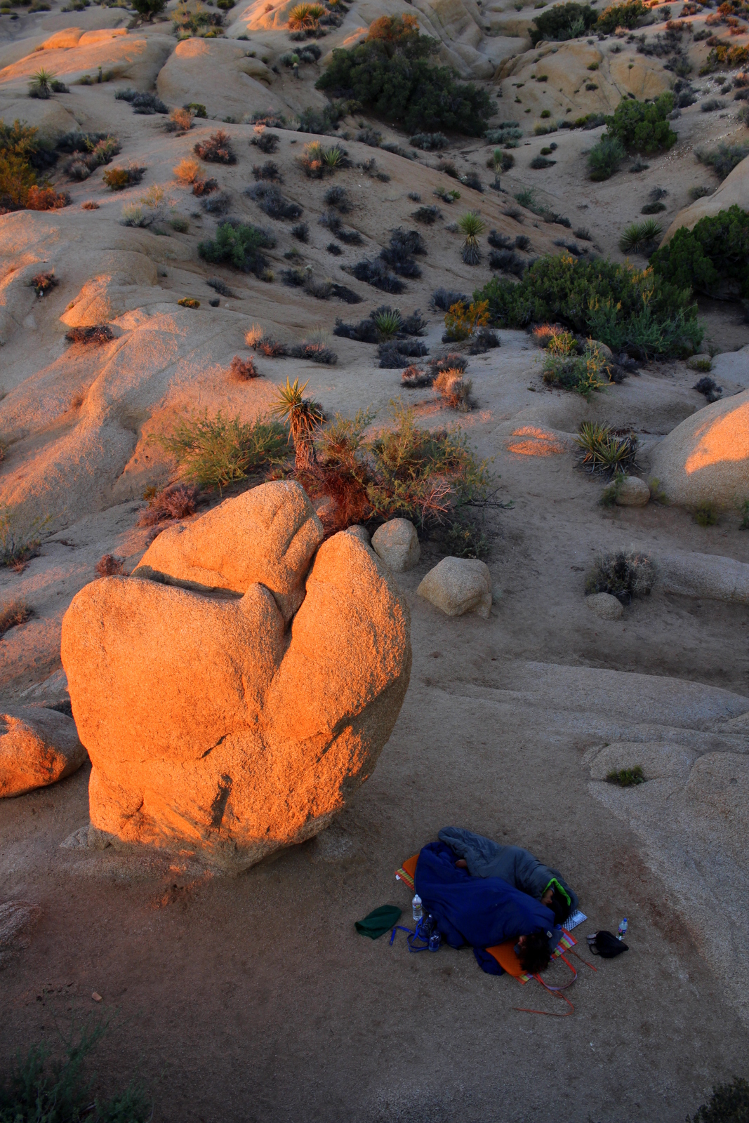
As I made my way to the shallower side of the rock, I looked down and noticed a couple who'd opted to sleep outside, between two rocks, and under the stars. They looked very peaceful.

I got back down to my campsite. I looked up at my wonderful perch for that morning (and the previous evening). I thought to myself how amazing it was that a few dozen feet of vertical could change your entire perspective on the world.

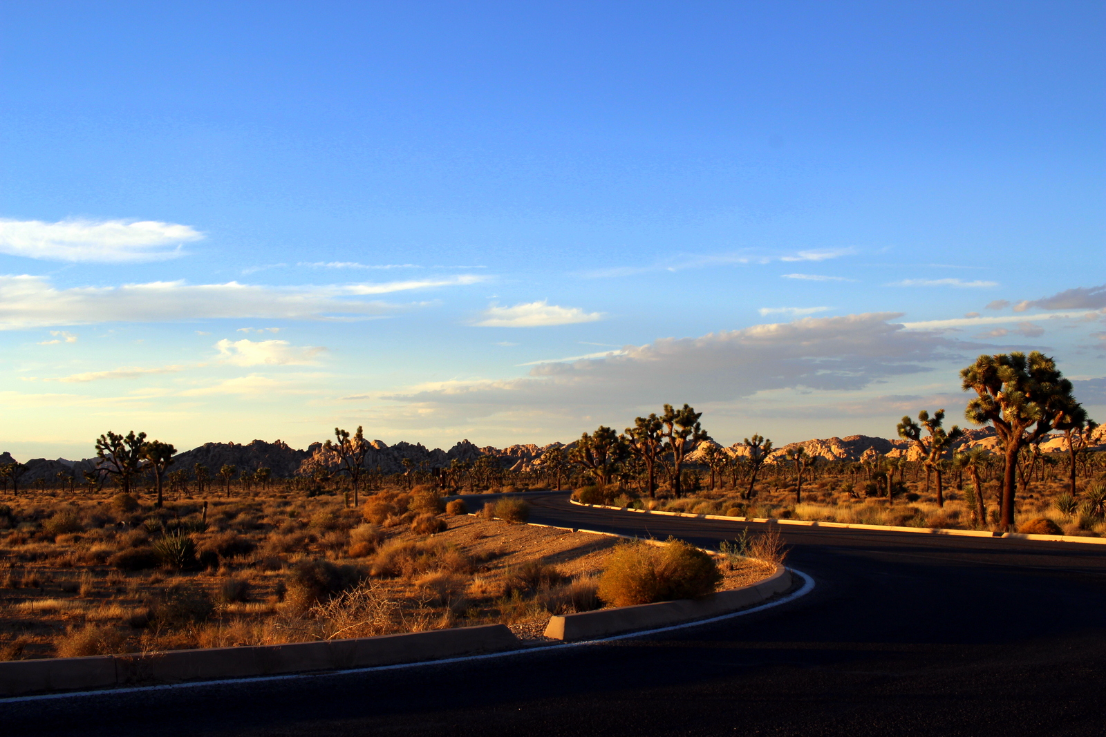
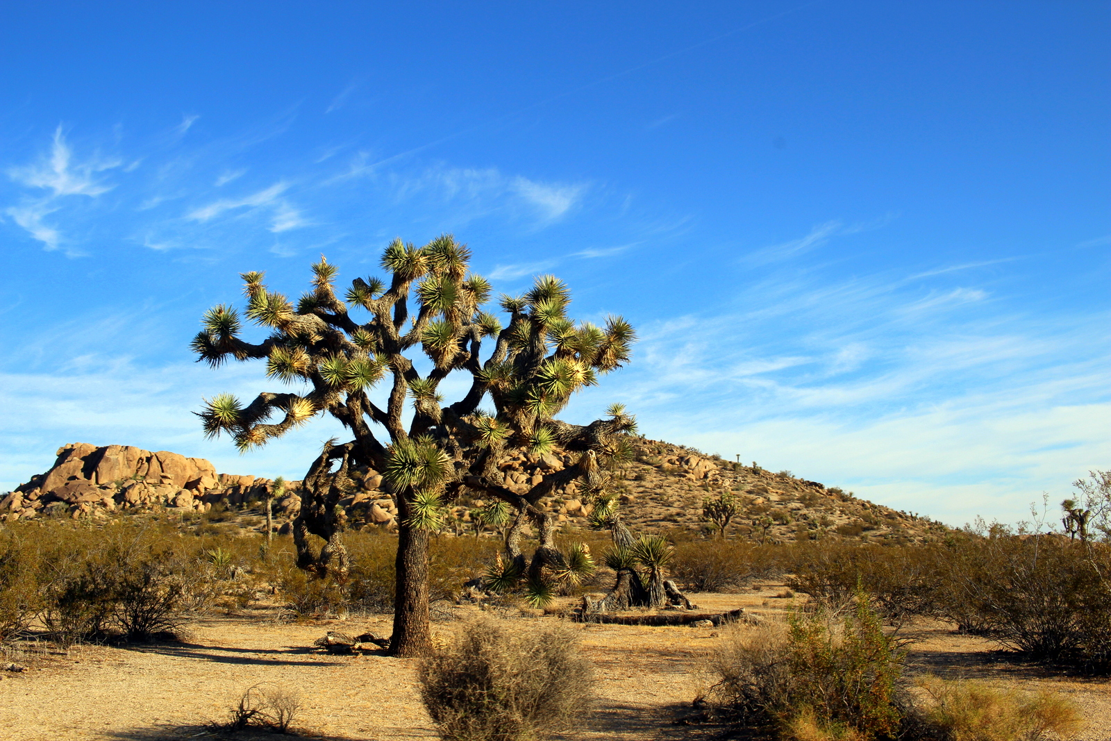
I cooked a quick batch of Birch Benders pancakes (amazing, as always!), and hit the road. I had over 350 miles to drive to my next destination, Zion National Park, so I had no time to lose. As I descended out of Joshua Tree, I decided I'd pull over and take one last photo of the eponymous tree. Their area is dwindling, so who knows if future generations will have the opportunity to see these weird plant/tree hybrids.

And then I was on the open road again.

I took a detour into the Mojave National Preserve. What a landscape! Right in the middle was an abandoned railroad town, Kelso.

It was crazy to think that during World War Two, Kelso was a boomtown. But it really just shows how fragile our lives and our environments are, and how things can happen that are entirely unimaginable. I'm sure the people who came and lived in Kelso never would've imagined that it would become a shell in the desert.

And then I cruised--into Nevada, past Las Vegas, through Arizona, and into Utah--to Zion National Park.

Day 29: Joshua Tree National Park, CA by Wookie Kim

Today was heart-pumping; I crossed paths with a rattlesnake and almost got stranded in the dark on top of a pile of rocks.

I'd enjoyed my day in the mountains, but I was ready to make it into the deserts of California. I'd find that at Joshua Tree National Park, just a couple hours east of Idyllwild.

I started the day slowly. I took advantage of the free Astrocamp breakfast (which made me miss the good old days of unlimited meal plans in college), and wrote a couple blog posts since I had wifi. Then I said goodbye to Kyle and made my way out of the San Jacinto Wilderness and down into the Coachella Valley. It was refreshing to start the day with a scenic drive down the east side of the San Jacintos.

Once down in the valley, I noticed something quite disturbing while cruising. The temperature.

Stepping outside for a lunch pitstop in Banning confirmed just how hot it was. Given that Rim-to-Rim was so close, I didn't want to bake in the sun. I was almost glad I'd be arriving at Joshua Tree late in the afternoon.

At 2:30 p.m., I arrived at the visitor center. I loaded up as many water receptacles as I could (there's no water inside the park), and headed in to find a campsite at the Jumbo Rocks campground, which is known to be one of the most unique and beautiful around. I managed to snag a nifty spot, right up against the base of a pile of jumbo rocks. I pitched my tent up against the rock, so that it would be in the shade. And then I was off!

My first stop was Barker Dam. Ranchers built this dam to provide water to cattle. It was a short loop, which, in this heat, was a good thing. As soon as I turned the corner, I noticed that someone was modeling on the rocks. I could see why. The backdrop was perfect.

I continued around the loop, and observed the varied plants and rocks. The clouds were pretty, too.

I finally made it to the dam. I was surprised by how much water was in the reservoir. If I were living here, I'd live right here, I thought to myself. (Life is always better near water.)

The loop ended quickly because it was just over a mile. But my little jaunt didn't end without a pleasant (and scary) surprise. Ahead of me, I noticed a couple stopped on the trail. Turns out a rattlesnake was rattling at them.

It also turned out that the rattlesnake simply wanted to cross the road. We stepped well back, and let it cross.

Ahead of us, there was another pair of hikers approaching. We warned them from afar that there was a rattlesnake on the trail. We all waited. Eventually, the rattlesnake made it to the other side. It then disappeared into a crack in the rocks (now I understood why the signs always say to never put your hand in a crack in the rocks!).

That was certainly an exhilarating way to end the Barker Dam loop. But I couldn't end the day with just 1.5 miles of trails! I was off to the Hidden Valley trailhead. The scenery was immediately different. It was far more rocky here.

I kept a chill pace, but wasted little time completing the loop. It was still really hot, even though it was past 5:30. I observed the cacti up close, and I also noticed that some hiker had left behind an unopened can of beer. I was tempted by it, but chose to leave it be.

My final stop for the afternoon was the Keys View. This was a high point facing the southwest and looking down into the Coachella Valley. On a clear day, you could apparently see the San Andreas Fault and even Mexico. Today was not a clear day. The smog hung thick in the valley. I later learned that Joshua Tree had the lowest air quality of all our national parks. This is because the pollution from major California cities (e.g., Los Angeles, San Diego, San Francisco) flowed with the easterly winds into the valley. It is the areas of land that are slightly inland that pay for the pollution created by coastal cities.

And then I was done for the evening. I headed back for Jumbo Rocks. I was ready to cook a quick meal, and then catch the evening ranger talk. Seeing the park as sunset was approaching was interesting because the land held a different hue. It was basically tinted orange.

I came back to Jumbo Rocks as the sun was setting. I climbed up a small pile of jumbo rocks and observed the campground. All around me, people were up on the rocks, taking selfies and just taking it all in. The purple-to-blue spectrum was a familiar one. It was still mesmerizing.

The ranger talk (my third) was on climate change. Ranger Christian went through a concise but compelling presentation on the way humans have contributed to the warming of our climate. He tied the global problem to the park itself--climate scientists predicted that, with the rising global temperatures, the Joshua tree would be close to extinct by 2100.

By the time I got back to my campsite, it was almost 10 p.m. I knew I needed to go to bed, since I wanted to catch the sunrise from atop the rocks. At the same time, the pile of rocks I wanted to view the sunrise from seemed challenging to climb. I decided I'd get on top of them now to preview their difficulty, and also try my hand at some night-time photography.

The pile of rocks I wanted to climb looked like a trail cairn, except, instead of little pebbles and stones, the cairn was made up of gigantic rocks. I'd seen it earlier, just after the sun had set. Now I would climb this pile.

I got 90% of the way to the top without any issues. I'd started (indoor) rock climbing with a coworker back in January, so I had at least some minimal rock climbing skills to put to use here. I'd mainly avoided the bouldering walls, but here I was, bouldering on actual boulders--and doing quite alright!

But the last rock was massive and steep and made me pause before climbing it. It was only a tad smaller than the rock right below it, which meant that any kind of "ledge" was very small; if I fell off, I'd fall a good 20-30 feet to the ground. It was also quite dark, which made it hard to see the rock's crevices (I did have a headlamp). In spite of this, I (foolishly?) ascended. I patted my hands around the sides of the rock, feeling for a crack or groove that my hand could securely grip. I then found a new foothold, stepped up, and repeated the process, step by step, as carefully as I'd ever done. I was almost to the top when I really started struggling. I needed just one more step with my right foot and then I'd be able to pull my body up the flat part of the rock. But I couldn't reach a good handhold. I paused briefly, took a deep breath, and reached up again. Finally, I'd found what I needed. I scrambled up to the top. I was now on top!

It was an amazing feeling. I'd not really planned to use my rock climbing skills on this trip. And here I was using them to my advantage, to get a great viewpoint. From the ground, the pile of rocks hadn't seemed that tall. But looking down, my tent seemed very small. I realized I was now quite high above the campground. Like towering high. And I'd just climbed up here spontaneously.

A view of my tent from the top of the pile of rocks. (This photo was actually taken the following morning, at sunrise.)

A view of my tent from the top of the pile of rocks. (This photo was actually taken the following morning, at sunrise.)

I was now ready to test some manual exposures. I wanted to see if I could capture the campground at night. Even though it was past 10 p.m. (and quiet hour time), I could hear and see lots of activity. Maybe I could capture it visually? The almost-full moon provided good ambient lighting, so I knew that I could get pretty clear views with a medium-length exposure. I finally settled on 8 seconds as a good exposure time. It was really cool to see the campground light up.

The camera, I was learning, was an incredibly versatile tool. It could capture light in a way that the human eye couldn't. I was impressed by what I had done without a tripod--I'd just balanced the camera on the rock, angled it, and hoped I could hold the camera steady with my hand. I now felt ready to capture the sunrise, and was doubly ready for bed. I put my camera away.

And then I panicked. I realized that I hadn't thought about how I would get down the pile of rocks. Generally, climbing down rocks in this situation is harder. Given how challenging the ascent had been, I wasn't sure how I'd manage getting down. I began by telling myself a lie: it would actually be easy to get back down. I tried. As expected, I soon reached a point where I felt like my feet were dangling, but I was still too far away from the boulder below me. I twisted my head and saw that the distance to the rock below was actually not that great. But--and this was an important but--because the rock below was almost the same width as the rock I was on, I had absolutely no wiggle room. That is, if I dropped down and rolled even a few feet, I'd go flying off the side.

This was a pretty scary moment for me, and definitely one that I hadn't intended to be in. In fact, this was the first time during this trip where I felt like I'd made a true mistake. I was frozen on the side of the rock. Thankfully,  while clung frozen, I was in a very secure position on the rock. But my mind was far from secure. It whirred, and calculated options: (A) try to reach one more foothold below, (B) drop down but risk tumbling off the ledge, and (C) scramble back up to the top and call to other campers for help.

I couldn't decide. I spent a minute or two, still frozen to the side of the rock, debating my options. Pretty soon, though, my palms were getting sweaty (and I obviously didn't have a chalk bag!)--I needed to act soon or I'd slip off anyways. Instead of hastily making a decision, I decided I'd go back up to the top and regain composure.

I'm glad I returned to the top. After taking 5 minutes to catch my breath and dry my palm sweat, I'd come up with a new option: (D) find another way down. I wasn't thrilled with this option, because on the first ascent, I'd seen no way up but the one I'd taken. But I figured it was at least worth a shot. It was certainly possible that there were some routes that were easy to do on a descent but hard to do on an ascent, and vice versa.

Turns out (D) was the right choice. I found a side of the rock with a shallow decline. I butt-scooted to the edge and saw a fairly wide mini-boulder below. I could climb down partially and drop down onto that boulder without the risk of falling off. And that's exactly what I did. Once I was on that mini-boulder, I easily descended back to my campsite.

I still couldn't believe what had just happened. I'd actually been contemplating yelling out to my campground neighbors, who I'd spoken to earlier, for help. I don't even know what help they could've provided, but that's kind of how desperate I was at the time. But I'm glad I took some time to make a calm, calculated decision, because that's what led me to climb back up to the top and brainstorm new possibilities. Sure, I could've tried option (B) while clinging to the rocks. In fact, I have a feeling that I could've dropped down and maintained my balance enough so that I wouldn't roll or fall over. But I thought about the outcome if I couldn't stay in one spot. And that was enough to make me reject that option.

This was a heart-pumping way to end the day. And what a day it was! As my adrenaline faded away, I became very sleepy. I crawled into my tent, closed my eyes, and sighed a deep sigh. And then I fell asleep.

Day 28: Idyllwild, CA by Wookie Kim

I felt like I was in a joyous summer camp. That's because I was.

After having an excellent brisket breakfast burrito from Coffee Commissary with Caitlin, I'd made it to the San Jacinto Mountains just 90 minutes east of Los Angeles, where I'd be staying with Kyle S., another good friend, this time from my Baltimore running days. Kyle was an instructor at Astrocamp, one of the country's best outdoor science camps. I'd be spending the day at camp, and in the San Jacintos. I arrived right at 12:30 p.m. Kyle was waiting for me. All around me, I could hear the shouting and laughter of rapturous young children on three- to five-day excursions here.

The staff had recently turned an ugly rock pile into a human foosball field. Naturally, this seemed to be the most popular area of the camp.

After lunch and a quick tour of the camp (and after wishing I was a middle schooler again, just so that I could come here one summer), Kyle took me through several of the classrooms and walked me through the demonstrations that he would normally use to teach students science.

In the atmosphere room, we played around with air pressure. Kyle used a vacuum to suck out the air in a chamber that had a beaker filled with water. By doing that, the water began boiling at room temperature. I hadn't realized (or had forgotten) that "boiling" doesn't imply being hot.

Kyle also poured out some liquid nitrogen, which was impressively cold, and impressively cool to see. 

The coolest part of the atmosphere room was burning hydrogen-filled balloons. Kyle filled a balloon with hydrogen gas, while I held a huge 3-foot-long lighter and popped the balloon. This would lead to a mini-explosion (we wore giant face masks). The second time around, Kyle filled the balloon with cupric chloride, which is what is used in fireworks. I decided I'd try to capture the explosion on film. Amazingly, I caught the green fireball cloud in the split-second that it appeared.

Then we went into the light classroom. I got a primer on the electromagnetic spectrum and he went through a variety of demonstrations that taught kids (and me) about light.

There was a phosphorescent wall (AKA a glow-in-the-dark wall) on which we shined both UV and infrared light. Because UV light is higher energy, the wall absorbed that light, whereas the infrared light didn't leave any mark. Here is my UV artwork (which looks like the northern lights, right?).

We also played with an infrared camera. He showed me how infrared would penetrate objects that visible light could not, and vice versa. I mostly just enjoyed seeing the heat the various parts of our bodies emitted on camera.

We made our way out to the "Lunar Lander" area. Basically, this is the egg drop for space nerds. Instead of dropping an egg from a given height, students dropped a water balloon off of the second floor onto scale landscapes that simulate Mars' terrain. This brought back memories of my egg drop days. I miss them.

Kyle showed me a bunch of other cool demonstrations--really, too many to even remember!--but I could quickly understand why kids would love this place.

But I ultimately wasn't here to learn astronomy. We set out to run in the San Jacinto Wilderness. Kyle wanted to show me some great views of the region, so we decided to do the South Ridge Trail, which takes you up to a peak at almost 9,000 feet above sea level.

We took the bumpiest dirt road I've ever been on. I felt like I was playing that minigame in The Oregon Trail where you have to navigate your floating wagon down a river while avoiding obstacles. The cracks were so deep that it looked like we were driving over scale models of the Grand Canyon. I bumped the bottom of my Prius several times. I winced each time, and visions of my car breaking down in the southwest deserts flashed before my eyes.

We made it to the trailhead, and I took the obligatory trailhead sign. And then we were off!

The trail was 4.1 miles one-way to the summit of Tahquitz Peak, and involved 2,000 feet of elevation gain. Because the Rim-to-Rim run was apporaching, I didn't want to burn my legs too much. So we only want just under 3 miles and 1,600 feet up. Along the way, Kyle led me to some really great viewing spots, some of which required rock scrambling to reach.

We reached another vista from which we could see Tahquitz Rock. This rock is special to rock climbers. It was the climbing rock that was used to create the Yosemite Decimal System, the primary method used to classify the difficulty of climbs.

We took some goofy photos from this vista. The views were great, except for the haze in the distance.

We were now at the bottom of the set of switchbacks leading to the very top. I didn't want to risk burning my legs. Kyle also noted how hazy the sky was--we wouldn't really get a better view 500 feet higher. So we instead turned around and bombed the descent. We zigzagged in combination, kind of like synchronized slalom skiiers. 

It was now 5:30 p.m., and dinner would end in 30 minutes. We carefully made our way back down the dirt road to Astrocamp, and chowed down on standard camp fare, which, for me, was like a 5-star hotel buffet. It turned out that that night, an astronomer from NASA's Jet Propulsion Laboratory was giving a talk to the camp about recent news regarding Pluto. We sat in on that presentation. I felt a little lost, because the speaker clearly assumed that the audience had deep knowledge on astronomy and recent developments with Pluto. But it was still fun nonetheless. I could see and feel the space nerdery all around me (I've never seen people so excited to go pick up stickers of the New Horizons space probe).

After the presentation, we showered and kicked back until it got dark. Tonight was space night, which meant that instructors would be showing the night sky to students. We came on the later end, and Kyle showed me a variety of objects, including the moon, Saturn, and several galaxies and nebulae.

I've talked about how this trip has been entirely humbling because it has forced me to grapple with the vastness of our natural world. But thinking in more depth about our universe is even more mindbogglingly humbling. For instance, Kyle mentioned how if the sun was the size of a period, our Milky Way Galaxy would be the size of the continental United States. As another example, Kyle noted that if two galaxies--each of which might contain 200-400 billion stars--were to come together, the probability that any two of those stars would collide would still be close to zero. That's how far apart the stars in those galaxies are. Think about that for a second. It's truly incredible to think about. We are way, way, way smaller than specks!

Day 27: Los Angeles, CA by Wookie Kim

The weather in southern California has been incredibly hot recently. I was planning to attempt the Rim-to-Rim Run in the Grand Canyon on Tuesday, so I decided I'd take today as easy as possible, and maybe even forego running altogether.

In the morning, Molly took me to a delicious breakfast spot, where I nommed on a huge breakfast sandwich and we sipped our refreshing Vietnamese iced coffees. I couldn't keep her all day, so she went her way and I went mine.

And my way today would be the Hollywood sign. I mean, why not, right? I'd looked up the various routes up to the sign and determined that I wanted to do the shortest distance, even if that meant the steepest climb. Given that the temps were hovering in the mid-90s, I simply wanted to reduce the time I spent outside baking in the sun. I opted for the trail to the Wisdom Tree and Cahuenga Peak.

I drove up into a posh hillside neighborhood in search of the trailhead. I got lost and had to ask a group of babysitters where I was supposed to go. They redirected me. Interestingly, this route has been known to disappoint. The trail goes up and above the Hollywood sign, but it only lets you see it from behind. There was ample warning of this at the trailhead (and ample graffiti).

As I was getting ready to start, I noticed another runner getting ready to go, too. I decided to ask her for advice on the trail. I learned that Maria was recovering from a hip injury, and that the incline of this hike was good for that. At this point, it was scorching, and I hadn't properly rehydrated from the day before (beer generally doesn't help). I made the decision not to run today. I'd just hike. It was fun chatting with Maria, so we hiked together.

The hike was surprisingly rugged and steep. The first 3/4 of a mile had the majority of the ascent. I think it was somewhere close to 800 vertical feet in that span. A mile or so in, we made it to the Wisdom Tree, which has become somewhat of an icon in the region for being the only tree to survive a 2007 wildfire. Hikers leave all kinds of cairns and notes with wishes and hopes and dreams. There is also a geocaching box in which people write messages as well. And, of course, there's free wifi at the top.

After a brief water break, Maria and I continued. Maria hadn't made it to the Hollywood sign since her injury, and she was determined to make it today. I gave her my trekking poles, telling her that they were tremendously helpful in maintaining balance and redistributing weight as needed. Ahead was Cahuenga Peak and, slightly below the communications tower, the back-side of the Hollywood sign.

On the final half-mile along the ridgeline, Maria pointed out a few landmarks. To our left, there was a cemetery where a lot of celebrities were buried.

The hike had started out really hot. But up here, the wind kept us cool. We finally reached the top and got our first close-up of the sign--from behind.

The day was hazy, so you couldn't really see that far. But it was still great to see the scale of L.A.--this is a huge city!

Hikers can't really get any closer to the sign than this. There's a fence and excessive signage that makes this clear. There are security cameras all over the mountain, and even on the letters. Trespassing is an easy way to send a police helicopter your way. As much as I wanted to go see the sign up close, I wasn't about to tick anyone off.

We turned around and carefully descended back to the trailhead and our cars. I'd enjoyed having Maria for company, and I learned more about what she did in the area. Turns out she was an actress, comedian, and improv artist.

It was now late afternoon, and I had a couple hours to kill before meeting my next friend for dinner. I decided I'd drive around in the hills and see if I could catch a glimpse of the sign from the front. I drove slowly through Hollywoodland and finally caught it through some palm trees.

I continued and eventually found myself in Lake Hollywood Park. There were a ton of tourists here, and I looked behind and immediately knew why. There was a great unobstructed view of the sign.

It was now almost 5 p.m., and I didn't want to take any chances with rush-hour traffic, so I headed towards Mohawk Bend, the evening's dinner spot. I met Caitlin H., a great friend from law school who was out here for the year clerking for a judge, and caught up with her. After dinner, we decided to head up towards Griffith Observatory, which is known for its panoramic views of the city.

The views were great. I love seeing cityscapes at night. You really get a sense not only of a city's scale, but also its activity (measured by the intensity of light in various regions).

It was a clear night, and the moon was particularly easy to see. I managed to hold my camera steady (it helps to have a built-in image stabilizer) and capture a few clear shots.

We didn't realize that the observatory itself was much more like a museum. There were exhibits on the universe, space, the solar system, and everything else related to astronomy. By the way, it was 9:30 p.m. on a Wednesday night and it was absolutely packed.

The best views were on the viewing terrace. Everyone was taking photos there. Caitlin and I asked a tourist with less-than-steady hands to take a photo of us before we headed back to her place in Burbank.

My first full day in Los Angeles involved no running, but it was a refreshing break--one sorely needed especially as I head into what I believe will be my most epic 10-day block yet.

Day 26: Channel Islands National Park, CA by Wookie Kim

We were pulling away from the mainland. It was a strange feeling. When I think of "national parks" I don't think of islands. But I was en route to Channel Islands National Park, one of our island-based parks.

The Channel Islands are a set of eight islands off the coast of southern California, of which five constitute Channel Islands National Park. The only way to get to the park is by ferries that leave from the coastal cities of Oxnard or Ventura, or plane. I'd decided to take the ferry to Santa Cruz, the largest island. As we were leaving the pier, we came across a buoy and saw several resting seals (sea lions?).

The sky was overcast, so I was a little wary of my day out on the island. But as we progressed away from the mainland, the sky cleared up, and the water turned bluer. It was turning out to be a nice day, albeit a hot one.

Finally, after just over an hour, we arrived at Scorpion Beach on Santa Cruz. The water was crystal clear. (I would later find out that it was crystal clean, too.)

I began in the visitor center, and looked at the scale model of the island. My plan was to ascend out of the beach and descend back over the other side of the ridge into Smugglers Cove. I heard the beach there was beautiful--a perfect place to touch the Pacific Ocean for the first time on this trip. The route was supposed to be 7 miles out and back. Given that it was 11 a.m., and the boat back to the mainland departed at 4 p.m., every day-tripper on my boat decided to go on a shorter hike, on the other side of the beach. Alone, I began heading up the dirt road towards Smugglers Cove.

Within 15 minutes, I was up on top of the small ridge. I could see the ocean, as well as Anacapa Island, also a part of the park.

From there, I turned inland, following a dirt road. I was a bit surprised; I'd not expected the island to look this barren.

Eventually, I made it over the ridge and found myself looking into Smugglers Canyon. I'd now descend to Smugglers Cove, which was at the bottom of the v-shaped notch on the right edge below.

I love fast descents. This one was fast. The decline was relatively modest, but still steep enough to fly. The trail was mostly dirt, with very few obstacles. I cruised down into the cove. A few seniors from the University of Santa Barbara were there, playing in the surf. I'd seen the Pacific almost a week ago, but hadn't yet touched the ocean, so I decided it would be a great opportunity to swim (and cool off--it had been an incredibly hot traverse). I was a bit worried about swimming in the ocean, because the salt and sand greatly increases the risk of chafing. Ironically, that aspect of the dip turned out to be fine. Stupidly, in hopping on some of the sharp rocks, I split open the skin on the bottom of my foot on one rock. Thankfully, it was pretty shallow. I cleaned the sand out from under my skin, and hoped that nothing worse would come of that misstep. The water was refreshing.

It was now past noon. After snacking on some food I'd brought (Channel Islands is unique in that you have to bring everything you'll need--aside from a couple pit toilets and a water spigot, there are no facilities on the island), I decided I was going to try and reach Montanon Ridge, one of the high points of the island, and the perfect place to see 360-degree views. It was a hot, sunny day, so I decided I'd run the rest of the day without my shirt. Shirtless, I began the ascent out of Smugglers Cove and continued up the ridge. The ascent was not insanely steep, but it got more taxing the closer I got to the ridgeline. 

I finally reached the ridge. On the other side of the ridge was fog and clouds. I loved being high up and seeing the mist flow over the top of the mountain and dissipate on my side of the island. I looked back to where I'd come from.

It was now getting really hot, and I was also out of water. So I decided I'd head back towards the beach, rehydrate, and also spend the hour before the ferry left cooling off at Scorpion Beach. On the way back, I saw a couple island foxes foraging for food. They were super cute, and didn't really mind my presence.

I made it back to the beach and found that most everyone was gathered there. People were chilling on the shore, splashing around in the water, snorkeling, kayaking, or stand-up paddleboarding. My core body temperature had risen--I could really feel the blood pulsing through my veins--and I used this time as an opportunity for a cool bath in the ocean. It was the perfect end to a great day on the island.

We loaded up and left promptly at 4 p.m. The return voyage included a special surprise. The captain had mentioned he had seen a pod of dolphins on the way over here. We would try and catch them on the way back to the mainland.

Not 10 minutes into our trip, we spotted our first dolphins. I scrambled to catch a glimpse, thinking that it would be hard to see them. I slightly regretted not bringing any other lens but my 24mm prime lens, which is meant for landscapes and has no zoom. 

What I didn't realize was that we eventually swam right over the pod--and that the pod included roughly 1,000 dolphins! They were like a swarm around our boat. Seeing all these dolphins frolicking in the ocean around us really brought a smile to my face.

Things only got better. The captain said he would create a wake, and that the dolphins would surf in that wake. Sure enough, as the captain sped up, we could see the more athletic dolphins surfing the wake created by the ferry. They jumped in and out, in and out. Again, I was smiling.

2015-09-22 17.17.00.jpg

I love moments like these. The ones that are so memorable but were completely spontaneous and unplanned. I'd had absolutely no expectations that I'd see any marine animals on the boat ride. And I'd gone whale watching and whatnot before. But seeing the thousand-strong pod was one of the coolest things I'd seen while on a boat.

We eventually docked in Ventura just past 5 p.m. I got into my car and booked it into Los Angeles. I was heading in to the city to stay with my friend, Molly Mitchell (of @meandmyboifriend fame). The traffic was wretched. I realized that L.A. was not the city for me. It was so spread out, and so car-filled, that I felt lost the entire time I was driving into the city. I was thankful for Google Maps.

After showering at Molly's (and realizing that running shirtless was a bad idea!), we headed out on Sunset Boulevard for burgers and, most importantly, churro ice cream sandwiches from Churro Borough. They were incredible.

It was another fulfilling day, this time in L.A. (rhyme intended!).

Day 25: Big Sur, CA + Santa Barbara, CA by Wookie Kim

Having spent my planned rest day yesterday sweating and cranking up hills, I decided I'd really take it easy today. This was partly out of necessity. My next destination was Channel Islands National Park, and I needed to be at the ferry pier by 8 a.m. the next day in Ventura, a city just west of Los Angeles. I was also planning to drive along the Pacific Coast Highway through Big Sur and knew that the windy coastal roads would make for slow progress. I had almost 400 miles ahead of me. It would be a long day.

But that didn't mean I wouldn't run. I'd stayed out late last night, catching up with friends, so it would've been nice to sleep in and just hit the road. But I chose to wake up at 5:30 a.m. and make my way over to Fort Mason to catch a workout, a gorgeous sunrise, and breakfast with the November Project SF tribe.

November Project has been an amazing part of my life over the past few years. I started working out with the Boston tribe, and then ended up with the Baltimore tribe this past year. The workouts are always great, but the camaraderie and community--AKA the people--is what makes NP so special. I felt completely at home during the workout, and had one of the coleaders, Paddy Ó Laoghaire, to thank for being so welcoming.

After returning to my friends' place to shower, I headed over to the Mission to visit Clever, a company that my friend, Dan Carroll, co-founded a few years ago. Clever has been revolutionizing the way teachers, schools, and school districts manage student data. In fact, just that morning, the New York Times had published a piece on the company and, as I arrived at the (gorgeous new) office, Dan was waiting in the reception area tapping out a Facebook post that shared the article. Dan gave me a tour of the office, and we chatted about the latest things Clever was pursuing and my trip. At 11, Dan had to leave for a meeting--and I needed to hit the road--so we parted ways. But not before I snagged a Clever t-shirt!

It's always inspiring to learn more about people and organizations that are doing great things. Dan and the Clever crew are certainly in that category. I was glad I'd visited.

I hit the road for Big Sur. There have been several moments where the driving has been on par with the running. Today provided one of those moments. As I drove on the Pacific Coast Highway, on the cliffs high above the Pacific Ocean, I felt completely at peace. The drive took forever, but that was okay. I got to see the coast like this.

Along the way, at Dan's recommendation, I stopped for a late lunch (AKA at 3:30 p.m.) at Nepenthe, a family-run restaurant built into the cliffs overlooking the coast. The Ambrosia Burger hit the spot, and the multiple glasses of iced tea gave me just the boost I needed to continue my drive.

I continued, taking in the coastal beauty. I even saw wildlife along the way. I believe these are California sea lions, but they were enjoying an evening nap on the beach.

Before I knew it, the sun had set. It was past 8 p.m., and I was just pulling into Santa Barbara, a coastal town a couple hours west of Los Angeles. I was pit-stopping here for the night in an Airbnb before heading to the Channel Islands the following morning. My hosts, Karen and John, were very kind, and directed me to Super Cucas Taqueria, which served up a phenomenal meal--exactly what I needed.

I love ending a long day with a solid meal (as opposed to pasta and tuna, my standard camping fare). I demolished the plate and retired for the evening, eagerly anticipating what awaited me tomorrow--Channel Islands National Park.

Day 24: San Francisco, CA by Wookie Kim

I woke up in a sketchy RV park. I was in no mood to hang out and cook pancakes. So I decided to hit the road and hope that something was open in Mendocino at 7 a.m. this Sunday. I found a family-run grocery store that had a breakfast bar--except everything was still cold or frozen. Turns out I needed to pick my food, pay for it, and then cook it using the microwave at the front of the store. It wasn't the tastiest meal, but it got the fueling job done.

And with that, I was off for San Francisco. The city has a weird place in my heart. I've spent most of my life living in, or being around, the east coast. That has meant that I've grown to become a person with a certain personality and vibe. At the same time, every visit I've made to the Bay Area has made me rethink whether I shouldn't just pick up and move west (actually, I've had similar feelings with respect to Portland and Denver). There's just something about the west coast lifestyle that I think matches my personality and passions. Most apparently, west coasters seem to weave outdoorsy things into their daily lives in a way that east coasters don't (or can't) do. And leading a healthy, balanced life appears to be more of a priority. The grass is always greener on the other side, though, so I have no real way of knowing whether this is just something that I'm sensing as an outsider.

I'd last been to the Bay Area in October. I was ready to be back. And I was ready to run in the Marin Headlands, a part of the Golden Gate National Recreation Area. When I visited last fall, I had the chance to run with Larisa Dannis, a high school classmate of mine who has been tearing up the ultra running scene lately. She had shown me a few of her favorite trails. I wanted to be back to explore more of them. Larisa was unable to join me on my run, primarily because of the intense mid-day heat. But I arrived at the Tennessee Valley trailhead and decided to set out for Muir Beach via the Coastal Trail.

I begin by descending the Tennessee Valley Trail towards Tennessee Cove. I didn't quite reach the beach, but it looked beautiful as I turned off on the Coastal Trail.

2015-09-20 12.39.29.jpg

Unsurprisingly, the Coastal Trail eventually took me out to the coast. It was a hot day, but the sky was remarkably clear.

I'd planned for today to be a rest day, but I knew that the heat and the hills would prevent that from happening. Still, I kept my pace as easy as I could under the circumstances. Soon, I made it to Pirates Cove, which was just over the first major hill.

I continued and made it to the hill that overlooked Muir Beach. Behind me was the beautiful beach at Pirates Cove. Looking forward, I could see plenty of people taking advantage of a perfect beach day at Muir Beach.

I decided not to descend into Muir Beach. It was hot, and that would add both time and effort, things I didn't not want to expend at this point. I had things to do, people to see! So I backtracked to the Tennessee Valley trailhead, toweled off the dirt caked onto my sweat and sunscreen, and made my way into San Francisco. A few miles into my drive, I'd passed through a tunnel and had my first view of the Golden Gate Bridge.

Each time I cross the Golden Gate Bridge, I'm reminded of the summer of 2006--the summer I biked 4,400 miles from New Haven to San Francisco. It was the best summer of my life, and the partial inspiration behind this summer's trip. I've compared that trip to this trip several times now, and I've realized that they are distinct in a variety of ways.

I made it into San Francisco, and immediately began meeting up with family and friends. I stopped to see my cousins and Abby, their new baby. I met up with other friends for afternoon beers at the Crafty Fox Ale House. I had dinner with more friends at Thep Phanom. And then I ended the day by cooling off with more beers at Toronado.

And just like that, the day was gone.

Day 23: Redwood National Park, CA + Mendocino, CA by Wookie Kim

My first stop today, after leaving Ed and Elsie's place just north of Crescent City, was Prairie Creek Redwoods State Park (the previous night, I'd run in Jedediah Smith Redwoods State Park, a different state park unit co-managed by the NPS). Prairie Creek was 90 minutes further south along the coast. I was running in another redwood forest because I wanted to see how they differed, if at all, in different locations. I also wanted to give running in the forests in daylight a shot.

But I had plenty to marvel at even before I got to Prairie Creek. From Crescent City, I took US 101, which in this part of the state is called the Redwood Highway. Very quickly, it took me out to the coast and to my first view of the Pacific Ocean on this trip. I immediately decided to stop.

As I continued driving, I made additional stops to take in the views of the coast. I also got to sea level and beneath the fog/clouds.

2015-09-19 12.32.42.jpg

After about 90 minutes of driving, I'd made it to Prairie Creek. I spoke to a park ranger about possible easy trails. I'd been feeling a little tired from my double-run day yesterday (summitting Mount Scott in Crater Lake and running the Boy Scout Tree Trail in Jedediah Smith), and wanted something relatively easy. The ranger suggested the eponymous Prairie Creek Trail, with the Western Ridge Trail as a higher-altitude add-on. I wasn't about to disagree.

Running in redwood forests is a soothing experience. You just feel very secure amidst these tall, wise, and powerful trees. Prairie Creek was unique because it had some of the tallest redwoods around. Redwoods are all up and down the coast, but the ones in this grove were particularly massive. This is the first extra large redwood I saw.

I made easy progress through the forest. The trail was soft and wide--perfect for an easy recovery day. I loved running between the big trees.

Just to show a sense of the scale, here I am standing in front of one of the massive trees I came across. My arm span doesn't even get close to the width of the tree.

The forest was surprisingly cool on a surprisingly hot day. But it was incredibly humid inside. I began sweating much sooner than I'd expected. As I was running, I kept looking up and cramping my neck a bit. There was just so much to see, and most of it was above eye-level. Heck, the exposed root system of a fallen tree was nearly double my height!

I particularly enjoyed seeing areas of the forest where sunlight shone in to create contrasts of light and dark.

I also continued playing while running between the trees. Here, I'm jumping off a little ledge between two trees.

I made it to the first intersection and proceeded up Zig Zag 1 to the West Ridge. It was a relatively steep ascent off of the forest floor. And I could finally now see the redwoods more at "eye level".

Running the ridgeline was a treat. I was a couple hundred feet above the creek, and it really felt cool to run high up and see redwoods in all directions. Again, the forest was just so impressive to see.

I made it off the trail at 2 p.m. I was starving. Back at the visitor center, I asked a ranger if there was food nearby. She mentioned that the first town I'd come across on the way south had a roadside burger shack that was delicious. I stopped for lunch at the Snack Shack, sat by the roadside, and ate a burger, just like she'd suggested.

I was still 4+ hours away from where I wanted to camp that night. I was basically still half a day behind, and hadn't made up the time. It didn't help that I drove slowly along the coast, stopping every now and then to take in the coast line.

As I continued driving south towards Fort Bragg and Mendocino, the sun finally set. It looked a bit like an atomic bomb blowing up on the horizon.

Given that it was a Saturday night on a weekend with nice weather, I should've planned ahead with lodging. I didn't. I ended up reaching the state park (Van Damme State Park) in which I'd planned to camp only to find out that all the sites had been taken. I frantically scrambled around the area, looking not only for other state park campsites, but also simply any inn, motel, or hotel that had availability. There were no rooms. Finally, at the entrance to one state park, a ranger gave me a sheet with a list of all the private campgrounds in the area. It was already dark, and I still didn't know where I was sleeping (was I about to sleep in my car for the first time?), so I dialed up each place with gusto. I eventually found an RV park that had tent sites available. I was the only tent in the entire campground. Let's just say I felt a bit out of place as a result.

I set up my tent, and then decided I'd head into Fort Bragg for dinner. I'd passed North Coast Brewing on the way down, and figured beers would cool me off after another great day on the trails. It was a delicious meal, and a delicious flight of beers. I returned to my tent, and nodded off almost immediately. 

It was another great day on the California coast.

On the halfway point--fears, nature, and journeys. by Wookie Kim

It's the beginning of day 23, which means that I'm at the halfway mark of my trip. By now, I've seen and done enough to have some thoughts on this journey. I wanted to memorialize some of them (even though I have to hit the road!). Here are rambles on fear, nature, and journeys.

*   *   *

Fear

In a way, part of the challenge of this trip--and part of what makes this trip so great--is that I'm confronting, and overcoming, a lot of my fears.

At the outset, I had so many fears. I feared that I'd get lonely traveling by myself; I've found my time alone incredibly valuable. I feared that I would get mauled by a bear; I've avoided that (thanks to my bear bell and bear spray). I feared that I'd get exhausted from driving and running all day, every day; I've found this routine surprisingly refreshing. I feared the bugs would invade my tent and swarm me; they've gotten inside, but I've learned to peacefully coexist with them. I feared that I would get lost on the trails; I have, but I've always found my way back. I feared I would twist my ankle; I've gotten close far too many times to count, but I've always regained my balance. I feared that I'd get bored; anything but.

And that's the beauty--none of my fears have taken control of me. Instead, I've conquered--or begun to conquer--them, day by day, step by step. Indeed, I've made it a point on this trip to follow what Eleanor Roosevelt advised people to do:

Do one thing every day that scares you.

Each day on the road presents a new opportunity to follow Roosevelt's advice. Last night, for instance, I ran through a secluded redwood forest after the sun had already set, with nothing but the light from my headlamp to show me the way out. It was scary, and I had goosebumps for the majority of the run, but I made it out safely, and life went on just fine.

One of the songs I've listened to over and over again on this trip is "All in a Day's Work" by Dr. Dre. Jimmy Iovine, founder of Interscope Records, opens the song with a short statement--one that I couldn't agree with more:

Fear, fear's a powerful thing. . . .  It's got a lot of firepower. If you can figure out a way to wrestle that fear to push you from behind rather than to stand in front of you, that's very powerful.

Think about how many times we spend our lives letting fear block us from pursuing our dreams. It really doesn't have to be that way. If we confront those fears, we quickly learn that they can push us even closer to those goals. This trip is showing me that.

*   *   *

Nature

I'm a city boy. I've spent most of my life growing up in the world's major cities (i.e., New York, Hong Kong, Tokyo, Seoul, Washington D.C., Boston, Baltimore). Although there are some exceptions, cities and nature don't do well together. As a result, a city boy like me never really had the opportunity to be immersed in nature, as I've been for the last few weeks.

Let me just say--it's important that every city person spend some time in nature. My time in the wild has taught me a lot. Most importantly, it has shown me that we are just specks. As I've cruised across the country, and trodden miles of wilderness, I've finally begun to get the sense of just how vast the natural world is, and how, in the grand scheme of things, each of us is just a tiny part of the world. It's been entirely humbling. But it's good to be humbled.

Living in the bubble of city life also means that you're shielded from thinking about the consequences that humankind can have on the natural world. We live a lifestyle of consumption--we constantly use up and discard things, even if we don't actually need them. That way of life is not sustainable; the time I've spent in our parks has heightened my awareness of this issue. At some of the primitive campsites I've spent time at, I've been forced to change my lifestyle to adapt to the limited resources. I thought this would be a hardship. But I've surprisingly found that life is okay, and sometimes even better, in a world of constraints.

This trip, in other words, has helped me draw a clearer line between my needs and my wants. I know what I need. Food, shelter, warmth, and direction(s). These needs need to be satisfied. My wants, on the other hand--well, they're just wants. Many of them (e.g. daily showers) are frivolous, and life is perfectly fine without them.

I hope to preserve this distinction when I return to my regular "city life". Simply put, I want to live in a way that best preserves this beautiful country and world for future generations. Such a lofty goal would seem to require serious sacrifices. But I've learned that I don't need to engage in heroics to do this. All it takes is little steps, little tweaks to habits. It takes a conscious decision, and I'm choosing to make it now. Hold me to it.

Journeys

Life is a journey (obviously). But it's better to think of life as a series of journeys, through different phases of life. We can have bad journeys, and we can have good ones. But no matter how you define your journeys, it's important to always seek them out.

Each new journey is an opportunity not only to experience the world, but to do so through a new lens. I'm only halfway through, but getting to see this beautiful country, and to feel beneath my feet the shifts in landscape as I've headed west, has been an important journey--one that I'll cherish forever.

I'm on the Pacific coast now (in northern California, to be precise). Over the next few days, I'll be making my way down the coast before I begin the return journey east. I hope the journey back will teach me as much as I've learned on the journey out.

Day 22: Redwood National Park, CA by Wookie Kim

The park police was waiting for me when I finished my run in Jedediah Smith Redwoods State Park (a park that is co-managed by the NPS). I'd squeezed this run into my already very long day, and I guess the officer wasn't happy about it. It was past 8 p.m., and it was pitch black deep in the redwood forest.

I'd spent the first half of the day making the rounds in Crater Lake. It had taken far longer than I'd expected to make it to California.

I didn't arrive at my Airbnb (this is my 3rd time using it this trip) until almost 6 p.m. Although the day was basically over, I wasn't about to let it end without a run in the woods. Redwood National Park is scattered and huge. But I wanted to see a little bit of each unit, so it made sense to run in one of the units tonight. Ed, my host, had mentioned that the Boy Scout Tree Trail was nearby. My national parks guidebook had also mentioned this trail as a must-do. I set out to run it.

I arrived at the trailhead right as two groups were getting off the trail. One group had turned around early because the sun was beginning to set, and they were worried it was getting dark. The other group had just finished. I asked them what the trail conditions were like. They said it was fine, but that the trail felt very long, and that it would get dark soon. I nodded. I realized that there were only two cars at the trailhead. They were the last of the day's hikers. I would be the only person on the trail.

I feared that I might be starting too late, that the forest would become dark while I was still running in it. This was a place with absolutely no cell service--deep in an old-growth forest. If I got lost in the dark, it would be a long, cold night of wandering.

I decided to chance it. I figured I could cover the 5.6-mile trail in about an hour so that I'd be back at my car at roughly 8 p.m. Knowing that sunset was around 7:30, I assumed that I'd have ample light until the last couple miles. I wasted no time. I was off chasing Fern Falls, the end of the trail.

I moved quickly, with fast leg turnover on the cushy dirt trail. I was determined to minimize the amount of time I spent running in the dark. It was a race against time. This also meant my photos were blurry.

I tried to make the most of my brief forest foray by looking around as I scrambled across the forest floor. These trees were incredibly beautiful--and huge!

I made it to Fern Falls in just under 30 minutes. I'd moved at a solid pace, given the undulating hills, and the root-laden trail I'd followed. I saw a massive fallen redwood that seemed like a continuation of the trail. I decided to see where it led. While tiptoeing across it, I looked down to the side and realized that, if I fell, I'd be stuck in a little ravine. The tree was so big that it was not resting directly on the forest floor. It was at this moment that I decided to turn around.

I booked it back to the car. But not before it got dark. It was already past official sunset, and I could sense it. There were portions of the trail where the trees were less dense. Between strides, I could look up and see the dark blue sky--it was not yet completely dark. But, pretty soon, I was in a part of the forest that was so dense that I looked up and saw nothing but black. I'd underestimated the thickness of the forest cover, and how that would prevent the already dwindling ambient light from hitting the forest floor.

Thankfully, I had my headlamp on me for the very purpose of providing lighting when the natural light went out. I used it to scan 10-15 yards ahead for obstacles, mainly roots, but sometimes also stumps. It continued to get darker. And the return leg seemed without end. As things became ever so slightly less well-lit, I started to make ever so slightly more errors. I began stubbing my toes on roots, and occasionally caught myself from twisting my ankle. I had quite the adrenaline rush come over me as I zigzagged back to the trailhead.

For the last mile, I ran in almost complete darkness. My headlamp lit the forest floor before me. It was so dark that I decided to also hold my iPhone and use the flashlight function to light the trail right in front of me. Despite the darkness, I moved at an even brisker pace. I was determined to get out.

I finally made it out. It had taken just over 27 minutes. Waiting by my car, however, was a park police officer. He had hiis heavy maglite out, and was walking around my car. When I arrived back at the trailhead, sweating buckets, and breathing somewhat hard, he asked me what I'd been doing. I told him I'd been running on the Boy Scout Tree Trail. He told me that people couldn't be on the trails after dark. I told him I was sorry, and that I was done for the evening. He said I was lucky--he was just about to give me a ticket when I'd arrived back at the trailhead. And then he left.

I changed out of my sopping wet running clothes, and took a moment to listen to the forest. It was extremely quiet, and I had the entire forest to myself. I hopped back into my car and drove slowly back to the highway.

Despite the literal and figurative stumbling blocks, tonight's was a good run. I'd tested my limits by running in near darkness. And I had no regrets.